Trail Mountain bike Porte des Pierres Dorées - Vtt : Pouilly, Crêt Lacrampe, Theizé - Photo

Vtt : Pouilly, Crêt Lacrampe, Theizé

© OpenStreetMap contributors
Length
Length
33 km
Max alt
Max alt
837 m
Uphill gradient
Uphill gradient
923 m
Km-Effort
Km-Effort  
45 km
Min alt
Min alt
230 m
Downhill gradient
Downhill gradient
924 m
Boucle
Boucle
Yes
Creation date :
2023-11-23 08:12:41.573
Updated on :
2023-11-25 08:23:19.277

(0 Reviews)

Mountain bike
Mountain bike
3h30
Difficulty : Difficult

Scan this QR Code to open this trail in the SityTrail application

FREE GPS app for hiking

Logo SityTrail SityTrail

IGN / Geographical institutes

Download SityTrail from the App Store Download SityTrail from Google Play

Logo SityTrail SityTrail Plus

The world is yours!

Download SityTrail from the App Store Download SityTrail from Google Play Download SityTrail on Huawei AppGallery

About

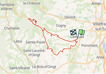
Trail Mountain bike of 33 km to be discovered at Auvergne-Rhône-Alpes, Rhône, Porte des Pierres Dorées. This trail is proposed by Mariolebeno.

Description

Pouilly, le Tacot, col du Chêne, Crêt Lacrampe par la droite (Pt 834 sur IGN), fontaine de Ânes, col du Joncin, Saule d'Oingt, St Abram, Theizé, Ruissel
Belle balade, très peu de route, tout se fait sur le vélo
Tout petit passage sanglier avant le col du Joncin qui peut s'éviter en prenant le bout de route jusqu'au col

Elevation profile

Positioning

Country:
France
Region :
Auvergne-Rhône-Alpes
Department/Province :
Rhône
Municipality :
Porte des Pierres Dorées
Location:
Liergues
Start:(Dec)
Start:(UTM)
628920 ; 5091644 (31T) N.


Close
My subscriptions